
Download the PicoR GPR device presentation
PicoR GPR is a geophysical device designed for subsurface sensing and monitoring of opaque environments – road pavement layers: asphalt, concrete, crushed stone, sand, soil, detection of inhomogeneities, anomalies. Based on the received data on the time of arrival of the reflected signal, the device allows you to calculate the thickness of the layers of the probed environments, detect and calculate the distances to inhomogeneities in the environments.
Due to the use of sufficiently high frequencies of the probing signal (1200 MHz or 1600 MHz), the depth of the GPR action is limited (50-70 cm). That is, it is guaranteed to receive a reflected signal from the upper layers of the road surface (asphalt, gravel), but due to the attenuation of the signal in the environment, it may not receive a reflection from the lower layers (sand, soil). However, it all depends on the specific conditions of use: the thickness and structure of the layers, humidity.
The main tasks solved by the device:
– for a construction contractor performing road work – to measure the thickness of layers of freshly laid asphalt and other materials without contact and without drilling with an accuracy of up to 1 cm to control the consumption of materials and meet the requirements for work, the processing result will be obtained a few minutes after the measurements;
– for the ordering or controlling organization that checks the quality of road works -to measure the thickness of asphalt and other materials layers without contact and without drilling with an accuracy of 1 cm throughout the entire length of the constructed (repaired) road along the entire width of the roadway to monitor the contractor’s compliance with the requirements for the work on the thickness of the asphalt layer and the thickness and structure of the entire road surface, the measurement result (full report) it can be received in a few hours.
The PicoR device does not replace certified measuring controls, but complements them. Relatively speaking, it shows “where you need to drill and take the core or work with an asphalt cutter.”
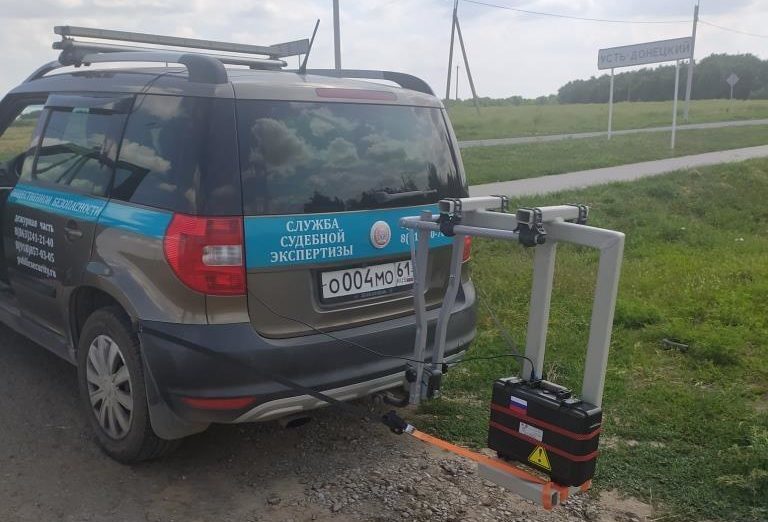
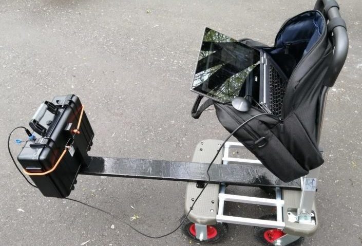
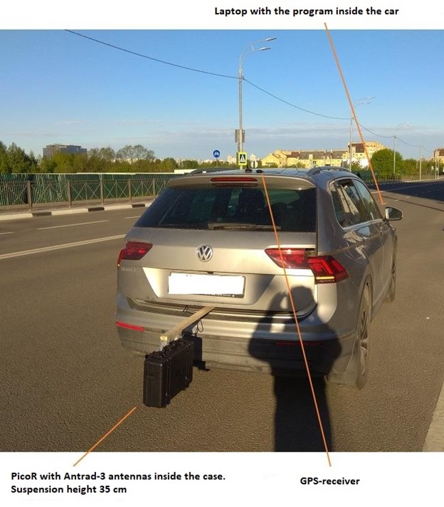
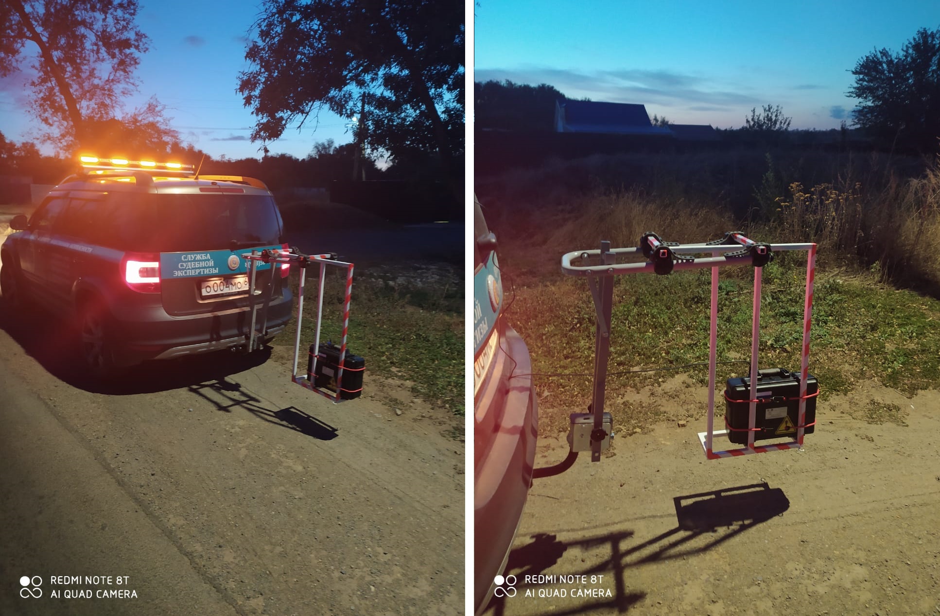
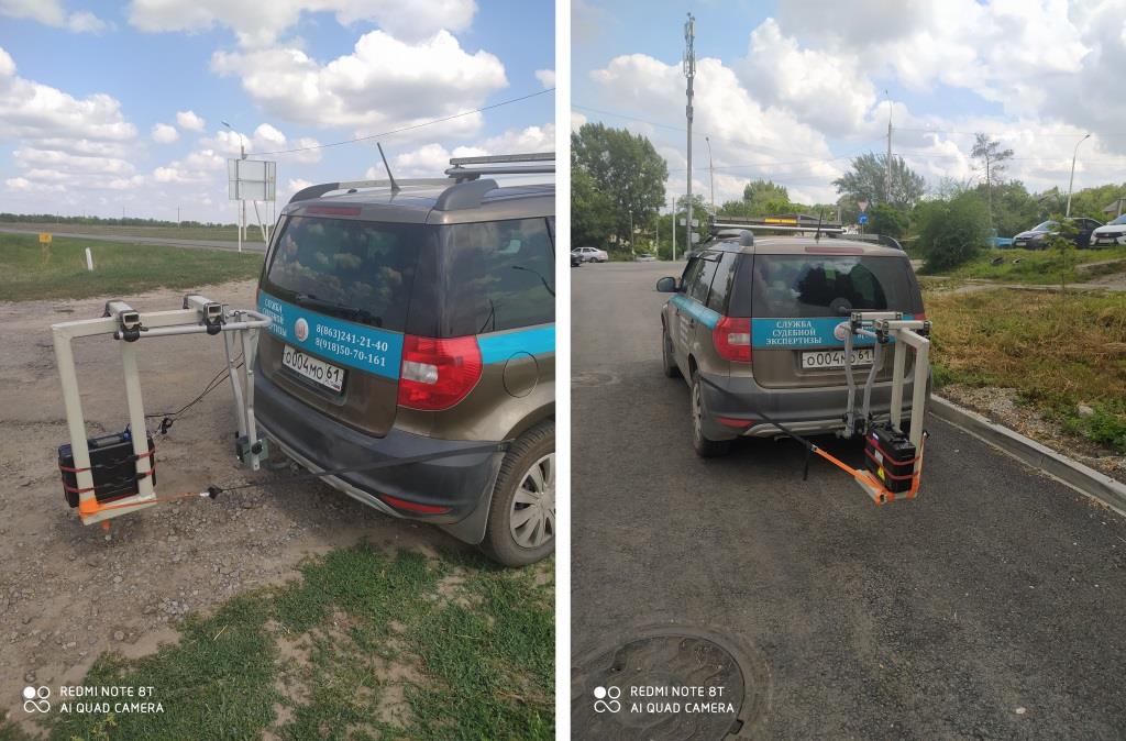
All measurements are carried out with geo-reference to the coordinates and subsequent display on the map of the area. The device can be used both in a transport version from a car, and in a portable one (or from a cart).
Advantages of using the device in comparison with the traditional method of determining the thickness of the pavement layers by drilling or cutting:
– significantly reduces the volumes of labor, time and the need to coordinate a variety of test drilling. To calibrate and verify the device data, drilling or cutting is required at 1-2 points, then the layers on the laptop screen are “tied” to the actual ones and can be determined throughout the entire length of the road section;
– measurements are carried out over the entire surface of the road section (in length and width), and not just at several points. Between these points there may be poorly executed areas that can be “seen” with the help of the device, but not with the help of drilling;
– the cost is several times lower than similar GPR devices;
– the device is easy to learn and in most cases does not require a geophysicist to interpret the data.
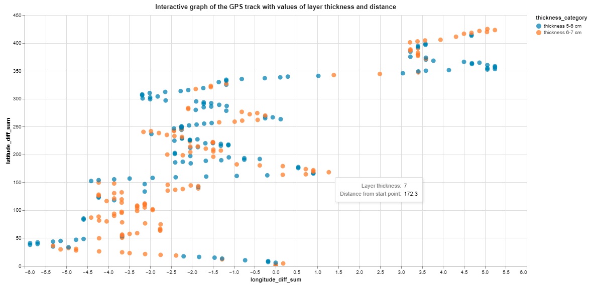
The software of the PicoR device after performing measurements allows you to get a visual profile of the road surface with reference by distance, a table with data of all measurements by layer thicknesses, coordinates and labels, build graphs with a profile of the layer thickness from the distance and a GPS track with layer thicknesses.
Equipment
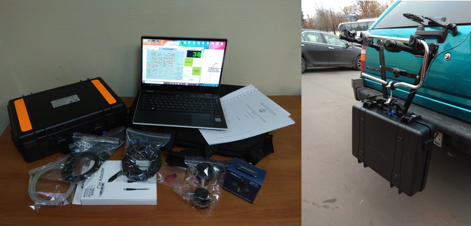
In the export version of the PicoR GPR device, we offer the following set of the device:
- RVS-M1 transceiver module;
- Antrad-3 UWB antenna for 1600 MHz antenna module – 2 pcs;
- Antrad-11 UWB antenna for 1200 MHz antenna module – 2 pcs;
- mini-USB cable with sealed connector, 2 m;
- mini-USB cable with sealed connector, 4.5 m;
- GPS-receiver with USB interface;
- USB extension cable, 3 m;
- PicoR software.
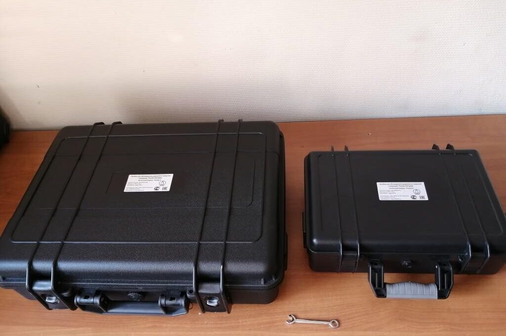
Additionally, the device requires a standard laptop and 2 protective cases as enclosures for antenna modules. This equipment, as well as the mounting options, is more convenient for the customer to purchase on their domestic market.
Parameters
| № | Name | Value |
|---|---|---|
| 1 | Measured thickness for road surface of antenna module with Antrad-3 (Antrad-11) antennas | 3…50 cm (3…70 cm) |
| 2 | Central frequency of antenna module with Antrad-3 (Antrad-11) antennas | 1600 MHz (1200 MHz) |
| 3 | Measurement accuracy | 1 cm |
| 4 | Resolution (minimum size of the object) | 3 cm |
| 5 | Battery life (powered by tablet PC or laptop and almost equal to their battery life) | up to 4-5 hours |
| 6 | Number of measurements per second (depending on settings) | 50 |
| 7 | Vehicle speed when attaching the device to the car (with 1 measurement every 10 cm) | 20 km/h |
| 8 | Height of antenna module above the surface | 20-40 cm |
| 9 | Field of view (diameter of the survey area) | 1 m |
| 10 | Distance between GPS coordinate points (at a speed of 20 km/h) depending on the receiver model | 1-3 m |
| 11 | Size of antenna module with Antrad-3 (Antrad-11) antennas (without housing) | 15 х 32 х 2 cm (33 х 41 х 2 cm) |
| 12 | Weight of antenna module with Antrad-3 (Antrad-11) antennas (without housing) | 0.3 kg (0.5 kg) |
| 13 | Operating temperature range of antenna module | -40 … +50 °С |
| 14 | Readiness time | less than 1 min |
| 15 | External interface of antenna module | mini-USB, sealed |
| 16 | Protection class of antenna module | IP67 |
| 17 | Computer operating system | Windows 7, 8, 10, Android (via remote desktop) |
| 18 | Data format compatibility with other programs | RadExplorer, GeoScan via MatLab converter |
Principle of operation
The principle of the PicoR operation is schematically shown in a figure. A pulsed ultra-wideband radio signal of low power is emitted by the transmitting antenna deep into the environment, reflected from the interfaces of environment with different permittivity, and received by the receiving antenna. After the initial processing and digitization, the useful signal is transmitted via a USB cable to the computer for further processing and visualization. The device is also powered via a USB cable, i.e. there are no batteries inside the antenna module placed outside.
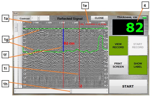
Information about the reflected signal is visualized on the radar image (radargram). The vertical axis counts the thickness (the time of propagation of the radio wave), the horizontal axis-the time (the number of measurements). The window shows the current layer thickness in cm. A map is opened in a separate window, where the GPS track of the device positioning is displayed, on which each point of the track corresponds to the value of the layer thickness.
How to work with the PicoR device
- Take measurements. To do this, attach the antenna module to the car (or the cart on foot mode), connect GPS receiver, run the program on a laptop, turn on the signal recording and drive along the entire roadway that needs to be examined.
- To quickly measure the thickness of the layers of the newly laid roadway, perform express signal processing at the work site. The device data is verified by measuring with a ruler along the edge of the layer.
- For the control measurement of the thickness of the layers of the newly laid roadway, drive with the device along the entire length of the constructed (repaired) road, if necessary several times to cover the entire width of the roadway and collect the necessary measurement records. The device data is verified by drilling and taking a core. Then process all the records according to the manual and make a report.
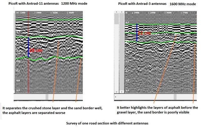
If there is a task of accurately determining the thickness of one or more layers of asphalt and crushed stone, then you should use Antrad-3 antennas and a frequency of 1600 MHz. In this case, the device has a higher resolution, and it is also more compact.
If it is necessary to determine the total thickness of the roadway (or the situation with it as a whole, for example, the presence of communications under the road), then use the Anthrad-11 antennas and the frequency of 1200 MHz. In this case, the device has a lower resolution, but a higher depth of action. But it must be repeated that sometimes the penetrating ability at this frequency will not be enough to see a thickness of more than 70 cm.

Software
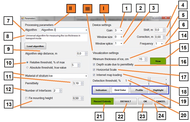
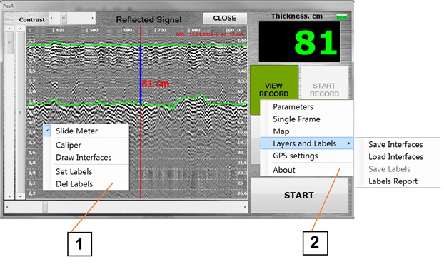
PicoR 5.0 software is used to control parameters of the antenna module, for visualization of reflected signal radargram (vertically – distance, horizontally – time) in real time, for record of reflected signal, for the use of different algorithms for automatically calculation the distance between the boundaries of the air-asphalt-crushed stone media, etc. and determine the thickness of each layer, record the track from the GPS receiver and display it on the map with reference to the measurement data of the device. It works under the Windows operating system. The figures below show the graphical interface and some of the functionality of the program (as an example, the ice environment is presented). Visualized information about the signal change over time in a density form is displayed in the radarogram window. Usually a layered structure with the clearest boundaries is visible, when measuring the distance between which the thickness of the corresponding layer is determined. The highlighted media boundaries are shown in bright green. The scale on the left shows the distance in meters, the scale on the right – in nanoseconds. The horizontal scale indicates the route number (measurement). The program provides for the device to operate in the recorder mode, i.e. to record files of an acceptable size without having to stop recording to save and start again, similar to the DVR function on a car. There are two context menus and an additional options menu for setting various parameters and calling tools. For a more detailed acquaintance with the program features, you can request the operating manual for the device.
Report
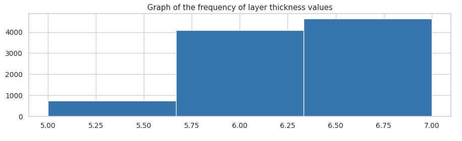
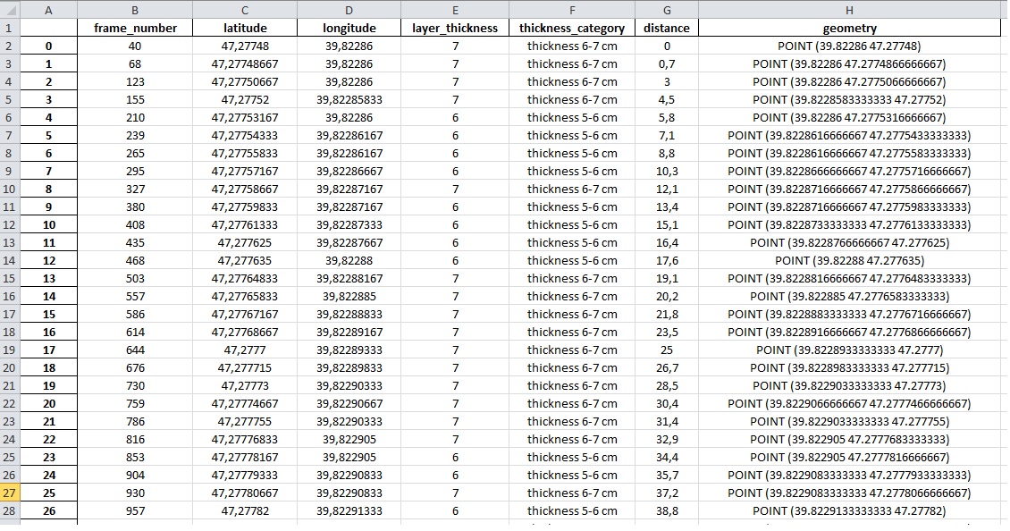
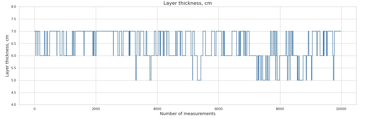
The analysis of measurement data and the preparation of the report must be performed on the record with fully correct layer boundaries. If there are incorrect border jumps in the record, they need to be corrected manually and save the correct boundaries using the appropriate tools. After processing the data according to the instructions, we will receive an Excel file with ice thickness data for each measurement, category by thickness, distance from the beginning of the measurement segment. Examples of graphs that can be obtained for the report are shown below.
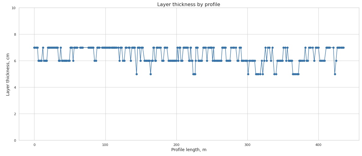
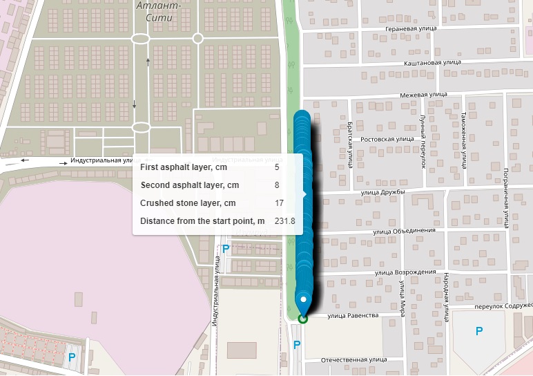
You can also get an interactive graph with a GPS track with a layer thickness, where you can find out the thickness and distance from the beginning of the track for each point by hovering the mouse cursor, zoom in on any area, and an interactive graph with a GPS track with a layer thickness immediately on the OpenStreetMaps map.
Work examples
In recent years, we have carried out a lot of work on adapting the PicoR-Ice device for ice and snow thickness measurement to the version of the PicoR GPR device for road surface inspection, working methods have been developed. Among our customers are forensic examination services, construction organizations. Several devices are now working in India, China, Canada.
Feedback
Below you can find reviews of our customers about the PicoR road GPR device, reports on the operation of the device, methods of working with georadar, presentation materials, certificates of the PicoR road GPR device, regulatory documentation.


